

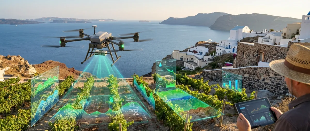
Five in the morning, Naxos. The sun is just hitting the tops of the olive trees when a DJI Agras drone lifts off silently over Giorgos Papadopoulos's grove. In 45 minutes it will have scanned 12 hectares, identified three areas of water stress, and flagged two trees suspected of Xylella fastidiosa. Giorgos checks the data on his tablet — five years ago, this job required three workers and two days on mule-back across his steep terraces.
📖 Read more: Satellite Internet Transforms Greek Islands & Remote Areas
This scene is no longer unusual on the Greek islands. Precision agriculture with drones is fundamentally changing how farmers work in island regions — precisely where traditional farming faced its biggest obstacles: steep terrain, fragmented plots, poor road networks, and sky-high logistics costs for supplies and equipment.
🛸 Why islands need drones more than anywhere else
Greece has over 6,000 islands, 227 of them inhabited. On most, agriculture remains a cornerstone of the local economy — olives, vineyards, citrus fruits, vegetables. But conditions are brutally challenging. The terraced farms of the Cyclades, the hillside plots of Lesvos, the slopes of Crete — landscapes built for mules, not tractors.
This is exactly where drones become a game-changer. An agricultural drone flies over terrain without roads, without slope limitations, without the fuel costs of heavy machinery. Technology that on the great plains of Thessaly is an optimization becomes a necessity on the islands.
Key application: The DJI Agras T40, the most widely used agricultural drone in Greece, can spray 21 hectares per hour with centimeter-level GPS accuracy. Its 40-liter tank delivers targeted spraying precisely where needed — no more blanket-spraying entire fields.
🛸 What drones actually do in the fields
Precision agriculture doesn't just mean “spraying from above.” Modern agricultural drones perform four core functions:
Crop monitoring
Multispectral cameras capture data at wavelengths invisible to the human eye. NDVI (Normalized Difference Vegetation Index) readings reveal where a plant is stressed, where water or nutrients are lacking, where disease is emerging — before it's visible to the naked eye. In olive groves, this technology is already being used to detect Xylella fastidiosa, a bacterium that can destroy entire trees and devastated millions of olive trees in southern Italy.
Precision spraying
Instead of uniformly spraying a 50-acre olive grove, the drone applies pesticide only where it's needed. The results speak for themselves: a 30% reduction in pesticide use, water savings, less groundwater contamination — critical on islands with limited freshwater resources.
Soil analysis and mapping
Drones equipped with LiDAR and thermal cameras create 3D maps of agricultural plots. On islands where land has never been properly surveyed, this becomes doubly valuable. OPEKEPE (the Greek Payment Authority for agricultural subsidies) is already piloting drone-based field verification, replacing time-consuming on-site inspections.
Livestock tracking
On islands with extensive livestock farming — primarily sheep and goats across Crete, Lesvos, and the Cyclades — drones locate herds in hard-to-reach areas, inspect fencing, and survey grazing land for early signs of overgrazing.
"With two flights a week, I see my olive grove better than my father did in a lifetime. I'm not replacing experience — I'm enhancing it with data."
— Farmer, Naxos (via AgroApps)
📖 Read more: 3D Printing in Schools: AI and VR Learning
🛒 Vineyards and olive groves: the ideal crops
Not all crops benefit equally. Olive groves and vineyards are the biggest winners — and that's no coincidence. In both cases, early disease detection means the difference between a record harvest and a catastrophe.
In vineyards, downy mildew and powdery mildew can destroy an entire crop in days. Multispectral imaging detects the first signs of infection 10-14 days before they become visible. On Santorini, where vines are grown in distinctive ground-level “basket” shapes to protect against wind, drones are the only efficient way to monitor large areas without physical access to every vine.
In olive cultivation, the bacterium Xylella fastidiosa remains the ultimate nightmare. Italy lost over 21 million olive trees in Puglia. Greece, with 132 million olive trees — most in island and coastal areas — cannot afford to gamble. Drones scan thousands of trees in hours, a task that would take weeks of manual inspections. Every infected tree caught early saves dozens around it.
🌐 The digital skills gap in farming
The technology exists. The money exists. What's often missing is the digital literacy. The average Greek island farmer is 57 years old. Familiarity with data analysis software, GPS waypoints, and flight planning isn't a given. Companies like AgroApps address this by offering an all-in-one service — the farmer doesn't need to fly anything: they receive reports with maps, spraying recommendations, and mobile alerts.
Meanwhile, ELGO-DIMITRA (the Greek agricultural research organization) and local learning centers are organizing precision farming workshops across island communities. In 2025, over 800 farmers on Crete, Lesvos, and the Cyclades attended training sessions. The goal: by 2028, every agricultural cooperative on an island should have at least two certified drone operators.

💰 Who's funding the transition
Precision agriculture isn't just a technology issue — it's an economic one. Greece has approved €35 million from its Recovery and Resilience Fund for agricultural technology, while the EU's Common Agricultural Policy (CAP) 2023-2027 explicitly encourages precision farming in areas with challenging geographic conditions — a category that covers nearly every Greek island.
In practice, this means subsidies for purchasing agricultural drones, pilot training, and establishing cooperative equipment-sharing structures. Because drones aren't cheap. A specialized mapping flight costs between €500 and €2,000 for small farmers — an amount that only becomes viable when cooperatives pool resources.
🔎 The pioneers: Crete, Naxos, Lesvos
Three islands stand out in agricultural drone adoption:
Crete: Greece's largest olive producer. Companies like AgroApps already provide drone services to olive groves in Messara and Rethymno. Multispectral analysis detects early signs of Xylella fastidiosa — the disease that destroyed millions of olive trees in southern Italy.
📖 Read more: Tap to Phone Payments Launch in Greece for Small Business
Naxos: With its diverse crops — potatoes, citron, livestock — Naxos has become a testing ground. The local agricultural cooperative adopted a shared drone for its 120 members in 2025. Results show a 25% saving on crop protection costs.
Lesvos: Known for its olive oil and ouzo. Here, the startup AgriTech Greece, in partnership with the University of Thessaly, is piloting a program to map 500 hectares of olive groves using drones and AI-powered data analysis.
Regulatory framework: Every agricultural drone flight in Greece requires EASA (European Union Aviation Safety Agency) certification. The “specific” category covers most agricultural spraying operations. Farmers need pilot training — a process many are calling to be simplified for small island farms.
▶️ From mules to megapixels
There's something romantic about the image of an old farmer with a mule on stone terraces. But the reality is harsh: island agriculture is losing hands, the average farmer is aging, young people are leaving. Drones don't replace humans — they give fewer people the ability to do more.
The 62-year-old olive farmer in Crete no longer needs to climb 40-degree slopes to check if spraying is needed. The 28-year-old agronomist in Lesvos analyzes multispectral data on her laptop instead of driving to three villages a day. The cooperative in Naxos shares one drone instead of buying three tractors.
The transition won't happen overnight. But with EU funding, Greek startups, and farmers willing to experiment, the islands are becoming a testing ground for an agricultural revolution that — instead of economies of scale — demands precision, data, and adaptability. Exactly what a drone delivers.
The next phase is already visible: autonomous drone swarms that collaborate, AI models trained on Greek crop varieties, integration of Copernicus satellite data with drone imagery. Rather than being left behind in agricultural technology, the islands may become the laboratory that shows the rest of the world how to do smart farming on difficult terrain.